
2020/02/02 - 2020/02/02
7344位(同エリア10467件中)
![]()
nomonomoさん
- nomonomoさんTOP
- 旅行記5490冊
- クチコミ9208件
- Q&A回答332件
- 6,833,928アクセス
- フォロワー104人


この旅行記スケジュールを元に
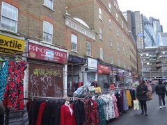
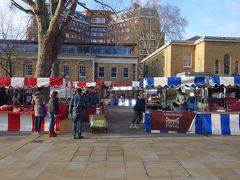
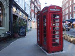
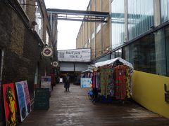
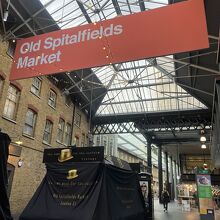
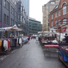
Old Spitalfields Market に隣接して(境がわからない)、新しいほうのSpitalfields がありまし。よくみると、"l"の代わりに'1' を使っているようです。Market という言葉も、積極的には、使っていなしようです。差別化の現われです。
- 旅行の満足度
- 3.5
- 観光
- 4.0
- ショッピング
- 3.5
- 交通
- 4.0
- 交通手段
- 鉄道 徒歩
- 旅行の手配内容
- 個別手配
-

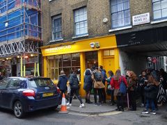
flying tiger
-
-
-
leon.
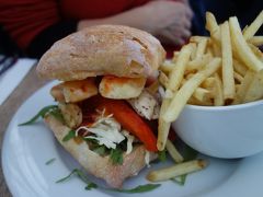
レオン (スピタルフィールズ店) ファーストフード
-
-
-
-
-
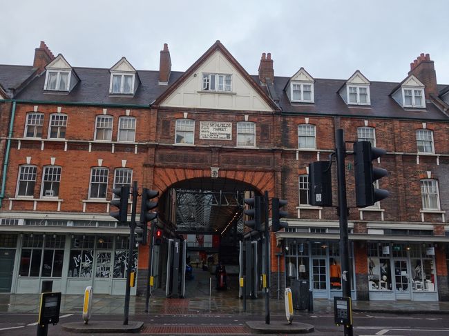
Spitalfie1ds の全容。Market の文字は、積極的には、使っていないようです。
-
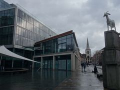
こっちは,'Old' のほうと違って,まったく新しい建物です。
-
斬新です。
-
History
Spitolfiels has been a settlement since Roman times, when it
was the location of one of London's largest Roman cemeteries
just outside the city. In 1197 the area became the site of a priory
called 'The New Hospital of St Mary without Bishopgate',
latterly known as St Mary Spital. This religious foundation was
one of the biggest hospitals in medieval England and was the
focus of a large medieval cemetery that included a
stone charnel house and mortuary chapel, now uncovered by
archaeoligists and to be seen nearby in Bishops Square.
In 1537 the priory leased the south part of its land to the
'Fraternyte or Guylde of Artyllary of Longebowes, Crossebowes
and Handcgonnes' for 297 years at a yearly rent of 20 shillings.
After Henry VIII dissolved the monastery in 1539, both the
gunners at the Tower and the Household Artillery Company
used this area known as the Old Artillery Ground to train and
test fire weaponry. In 1682 the ground was sold for
development, although many streets remain named in honour of
its historic use including Gun Street 12 and Artillery
Passage 8
King Charles II granted John Balch a Royal Charter that gave
him the right to hold a market on Thursdays and Saturdays near
Spital Square for 'flesh, fowl and roots', now Spitalfields
Market 13.
Very soon afterwards Spitalfields saw the arrival of French
Protestant (Huguenot) migrants. In 1685, King Louis XIV of
France revoked the Edict of Nantes and declared the religion
Protestantism to be illegal. Protestant services were forbidden,
Protestant children were to be educated as Catholics, and
emigration was prohibited. -
History
Britain welcomed 50,000 Huguenot refugees. A large number
settled in Spitalfields, working mainly in skilled trades such as
silk weaving and medical instiument making. They built chapels
for their congregatons as well as fine Georgian houses, many
with weaving lofts on top.
The Huguenots led the development of the garment industry
and the rise of Petticoat Lane market, and the expansion of
Spitalfields fruit and vegetabl a market. The area was also known
for its cobbles, shoe makers, milliners and tailors.
By the mid 1800s the Huguenot communities had largely been
assimilated into the mainstream population, and Jewish migrants
were pouring into the area (where there was already a
long-standing Jewish population), fleeing persecution in Eastern
Europe. They too worked in the fashion trades, in the street
markets and also in tobacco. By the turn of the 20th century
there were over 125,000 Jews in the East End, with many
synagogues, some adapted from Huguenot chapels.
Jewish people brought with them Ashkenazi foods and kosher
cuisine; breads such as bagels and meats such as salt beef. In
1860, the first fish and chip shop in Britain was founded at Mile
End by Joseph Malin who married together 'fish fried in the
Jewish fashion' with chips, later to become a British staple food.
There was incredible political activism in the midst of poverty.
Trade unions and political associations flourished in response to
social injustice and terrible working and living conditions. In
888 the East End News called Bell Lane 5 'the worst area in
all London'. The density of population was 800 to an acre - the
average for London was 50. -
History
The commercial, market and community life of the area were, as
now, closely linked. Sandys Row Synagogue 4 was the
administrative centre for the Stepney and Whitechapel Street
Traders Association for many years. New community welfare
and educational organisations sprang up, many years before the
state offered such support.
In the decades followmg World War II, younger Jews moved out,
and the Jewish community in the area declined in number. In
1986, Spitalfiells closed as London's commercial market for fruit
and vegetables before moving to Leyton. In recent decades a
wave of Bengali migrants has added its rich influence to this
unique cultural crucible, particularly around Brick Lane 14.
Local Spitalfields residents have worked hard to ensure this
multi-layered story is preserved and brought to life in the area.
For more information on the history of the area, including
information in different languages, please go to the website link
shown below.
www.towerhamlets.gov.uk/culturaltrail
The Cultural Trail is funded by planning contributions from the
Bishops Square development. -
Key
You Are Here
Other Information
(1) Brushfield Street
(2) A Gold, 42 Brushfield Street
(3) Christ Church Spitalfields
(4) Sandys Row Synagogue
(5) Bell Lane
(6) Former Site of The Jewis Board of Guardians
(7) Tenter Ground
(8) Artillery Passage
(9) 56-58 Artillery Lane
(10) Former Site uf Providence Row Night Refuge
(11) Jewish Soup Kitchen
(12) Gun Street
(13) Old Spicalfields Market
(14) Brick Lane
Places of Interest
Brushfield Street (1) provides one of the finest vistas in
east London with Christ Church Spitalfields to the east,
the Victorian architecture of Old Spitalfields Market and,
on its south side, a row of 18th century houses and shops
(an example being A Gold at 42 Brushfield Street (2) with
its preserved Jewish hallinery frontage).
Christ Church Spitalfields (3) was built between 1714
and 1729 to the designs of Nicholas Hawksmoor. One of
the finest Baroque churches in England, it was saved from
demolition in the 1980s by the Friends of Christ Church,
who inaugurated a full scale restoration with the help of
donations and Heritage Lottery funding. Its galleried
interior has been faithfully recreated. This parish was
carved out of the huge medieval Stepney parish as a show
of Anglican authority in an area then dominated by
Huguenots and other religious 'dissenters'.
Sandys Row Synagogue (4) was built as l'Eglise
d'Artillerie in 1763-6 for a Huguenot congregation, and
was entered from the alley known as Parliament Court to
the east. In 1354 the mutual aid (Friendly) society
'Loving-kindness, Truth and Care of the Bereaved' was
founded by 50 newly arrived Dutch Ashkenazi Jewish
families. By the mid 1860s the community had 500
members and needed a place of its own to worship. The
chapel, with its upper gallery and west-east axis was
available. A new entrance building on Sandys Row was
constructed so that the synagogue faced east towards
Jerusalem. The development by architect NS Joseph was
a source of much controversy because of the opposition
of his brother-in-law the Chief Rabbi. Consecrated in
1870, the vestry and synagogue sanctuary have been
described as 'hidden architectural gems', and in one space
tell the story of migration and settlement over three
centuries.
Established before the modem welfare state, key
community institutions were set up on or around
Petticoat Lane. The Jews Free School has its origins in
1732, with the foundation stone laid In Bell Lane (5) in
1820. Between 1880-1900 one third of all London's
Jewish children were educated there. Indeed in 1900, it
was the largest school in Europe with approximately 4000
pupils. Every child was clothed by benefactors.
The Jewish Board of Guardians was established in 1859 to
'attend to the relief of the strange and foreign poor'.
From 1896 to 1956 it was based in Middlesex
Street (6) working tirelessly to try to prevent Jews
entering the workhouses. It is now Jewish Care, and is
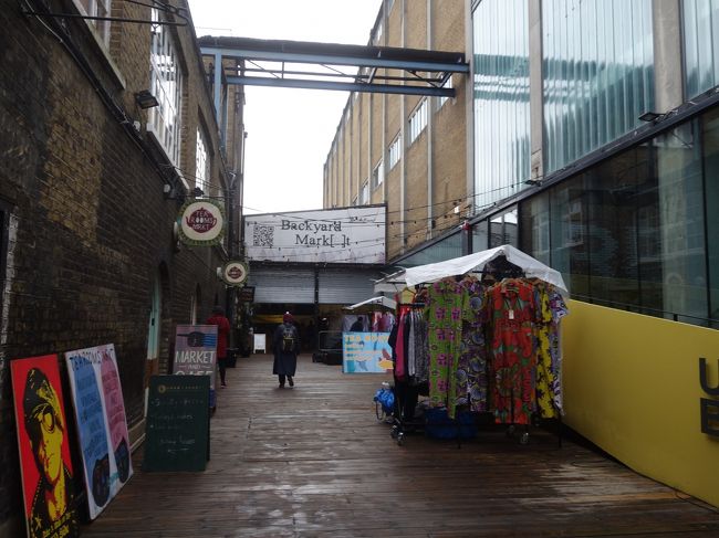
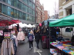
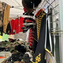
Britain's largest Jewish charity.現代的な建物の中で,おしゃれな洋服を売る個性的な個人商店が並んでいます。Old Spitalfields のとなりです。 by nomonomoさんスピタルフィールズ マーケット 市場
-
以上で、新しいほうのSpitalfields が終了。
次へいきます。 -
見慣れた道を通って、
-
そう、
-
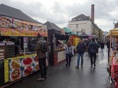
Petticoat Lane を、再度、通り抜けるのです。
-
買う物は。。。
-
どうしましょうか。
ペチコート レーン マーケット 市場
-
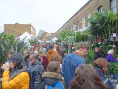
古い町並み。むかしのこの地区は。。。で有名とのこと。
-
そんな気もします。
-
あっちへ。
-
Brick Lane を目指します。
ブリック レーン マーケット 市場


この旅行記のタグ


利用規約に違反している投稿は、報告する事ができます。
旅行記グループ
London, winter 2020 (2)
-
前の旅行記
London(5.2) Old Spitalfields Market は古さと新しさが同居している。
2020/02/02~
ロンドン
-
次の旅行記
London(5.4) Backyard Market は屋内のマーケット。おしゃれで、品がある。
2020/02/02~
ロンドン
-
London(4.1) 今日からBrexit。喜ぶ人は喜んでいますけど,どうなるのでしょうか。
2020/02/01~
ロンドン
-
London(4.2) Partridges Food Market から朝がはじまります。
2020/02/01~
ロンドン
-
London(4.3) Sloane Street を歩く。お金持ちの,お金持ちによる,お金持ちのためのスト...
2020/02/01~
ロンドン
-
London(4.4) British Museum は古代文明にくわしい。今回はギリシャとアッシリアを見ま...
2020/02/01~
ロンドン
-
London(4.5) Little Venice で水遊び。ロンドンにもヴェニスがあるのです。
2020/02/01~
ロンドン
-
London(4.6) The Quince Tree Cafe で植物に囲まれて、素敵なランチをいただきま...
2020/02/01~
ロンドン
-
London(4.7) Marylebone High Street を Baker St. から Oxfo...
2020/02/01~
ロンドン
-
London(5.1) Petticoat Lane Market は洋服中心の路上マーケット。安い。
2020/02/02~
ロンドン
-

London(5.2) Old Spitalfields Market は古さと新しさが同居している。
2020/02/02~
ロンドン
-
London(5.3) 新しいほうのSpitalfie1ds は"l"の代わりに'1' を使っている。
2020/02/02~
ロンドン
-
London(5.4) Backyard Market は屋内のマーケット。おしゃれで、品がある。
2020/02/02~
ロンドン
-
London(5.5) Brick Lane Market は,その猥雑さに脱帽。ディープな下町ですね。
2020/02/02~
ロンドン
-
London(5.6) Columbia Road Flower Market。花の多さと、人の多さに圧倒さ...
2020/02/02~
ロンドン
-
London(5.7) The Princess of Shoreditch までローストビーフを食べに行っ...
2020/02/02~
ロンドン
-
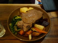
London(5.8) Oxford Street ですてきなランチ。ローストビーフをいただきました。
2020/02/02~
ロンドン
-
London(5.9) Carnaby StreetにKingly Court。Sohoは次々と新しくなって...
2020/02/02~
ロンドン
-

London(5.10) Liberty の Arthur's Restaurant でお茶しました。ケーキ...
2020/02/02~
ロンドン
-
London(5.11) Regent Streetのお散歩。Oxford CircusからPiccadil...
2020/02/02~
ロンドン
-

London(6.1) Underground Piccadilly Line で Heathrow Air...
2020/02/03~
ロンドン
-

London(6.2) Heathrow Airport Terminal 5 の散策。時間つぶしです。
2020/02/03~
ロンドン
-

BAのオンボロ B777 に乗りました。機齢19.4年。LHR-HND。 最悪のフライトでした。
2020/02/03~
ロンドン
-

羽田空港で久しぶりの和食を食す。日本は食事のバラエティーが豊かです。
2020/02/04~
羽田
-

羽田空港で日がな飛行機の発着をみる。あきないですね。
2020/02/04~
羽田
-

Boeing737-800 に乗りました。HND-NGO JL209。あっという間に名古屋に着きました。
2020/02/04~
羽田
旅行記グループをもっと見る
コメントを投稿する前に
十分に確認の上、ご投稿ください。 コメントの内容は攻撃的ではなく、相手の気持ちに寄り添ったものになっていますか?
サイト共通ガイドライン(利用上のお願い)報道機関・マスメディアの方へ 画像提供などに関するお問い合わせは、専用のお問い合わせフォームからお願いいたします。
この旅行で行ったスポット
この旅行で行ったグルメ・レストラン

ロンドン(イギリス) の旅行記


ロンドン(イギリス) の人気ホテル

フォートラベル公式LINE@

おすすめの旅行記や旬な旅行情報、お得なキャンペーン情報をお届けします!
QRコードが読み取れない場合はID「@4travel」で検索してください。
\その他の公式SNSはこちら/


旅行記グループ London, winter 2020 (2)
0
25