ニューヨーク旅行記(ブログ) 一覧に戻る
High Line をちょっとだけ歩きました。北端,Hudson Yards の回りだけです。景色の良いところです。

NYCを歩く。(6.7) High Line のお散歩。といっても,Hudson Yards の回りだけ。

5いいね!

2019/08/22 - 2019/08/22

5826位(同エリア8980件中)

0

45

nomonomo

nomonomoさん

この旅行記スケジュールを元に

High Line をちょっとだけ歩きました。北端,Hudson Yards の回りだけです。景色の良いところです。

旅行の満足度
4.0
観光
4.0
交通
4.0
交通手段
徒歩
旅行の手配内容
個別手配
  • Vessel を後にして,外を歩きましょう。ハイラインを歩くことにしました。

    Vessel を後にして,外を歩きましょう。ハイラインを歩くことにしました。

    ベッセル (ハドソンヤード) モニュメント・記念碑

  • 西の方角。車両基地を一回りします。

    西の方角。車両基地を一回りします。

  • 後ろを振り返ると,この景色。

    後ろを振り返ると,この景色。

  • Vessel の評価はどうなのでしょうか。

    Vessel の評価はどうなのでしょうか。

  • 今後,この建造物がニューヨークの象徴になります。

    今後,この建造物がニューヨークの象徴になります。

  • 象徴として,自由の女神を上まわるでしょう。

    象徴として,自由の女神を上まわるでしょう。

  • 特異な建造物です。だれの設計でしょうか。

    特異な建造物です。だれの設計でしょうか。

  • ハイラインのほぼ北の端。黄緑と緑のさかい。わかりますか。ここが今いるところ。ここから緑の部分をぐるっと歩きます。ちょっとです。

    ハイラインのほぼ北の端。黄緑と緑のさかい。わかりますか。ここが今いるところ。ここから緑の部分をぐるっと歩きます。ちょっとです。

  • 30フィートを上りました。南の方角。このはるか先にWhitney Museum があります。

    30フィートを上りました。南の方角。このはるか先にWhitney Museum があります。

  • 北の方角。これから歩くほうです。

    北の方角。これから歩くほうです。

  • 後ろを振り返ると,

    後ろを振り返ると,

  • 再開発地域。

    再開発地域。

  • ビルの高いのも目に付きます。

    ビルの高いのも目に付きます。

  • ハイラインの歴史の説明。<br />INTERIM WALKWAY <br />The opening of the High Line at the Rail Yards completes the northernmost phase of the park, connecting Gansevoort Street to 34th Street. Unlike the High Line to the south, this section features a simple path through the existing self-seeded plantings. The design celebrates the iconic urban landscape that emerged after the trains stopped running and highlights the expansive views of the Hudson River to the west and the City to the east. There are limited amenities in this section. Public restrooms are located at 16th Street and Gansevoort Street. <br /><br /><br />FREIGHT RAIL ON MANHATTAN&#39;S WEST SIDE <br />The 19th century brought a population boom and rapid growth in manufacturing to New York City. To serve the growing metropolis, freight rail lines were constructed along the city streets and waterfronts. The High Line was built by New York Central Railroad between 1929 and 1934 to eliminate street-level train crossings from 34th Street to Spring Street in an effort to improve both efficiency and public safety. <br /><br />For years the High Line served as an integral part of Manhattan&#39;s industrial landscape - the &quot;Lifeline of New York.&quot; The elevated railway allowed for efficient deliveries of meat, produce, and dairy products into the warehouses and factories up and down the West Side. Yet with the decline of manufacturing in Manhattan, train traffic in the 1950s and 1960s began to decrease on the High Line, and the elevated railway fell into a state of disuse. <br /><br />In 1999, CSX Transportation, the national rail freight carrier and then-owner of the High Line, commissioned a planning study to assess the reuse of the elevated railway. That study was presented at a Community Board meeting in West Chelsea, inspiring two neighborhood residents, Joshua David and Robert Hammond, to create Friends of the High Line, an organization to advocate for the adaptive re-use of the High Line. <br /><br />Following years of collaboration with the City of New York and Friends of the High Line, in 2005 CSX donated the High Line to the City of New York, paving the way for the High Line to be opened to the public. <br /><br />The West Side of Manhattan has been transformed from an industrial district into residential and commercial neiborhoods with new parks and cultural …

    ハイラインの歴史の説明。
    INTERIM WALKWAY
    The opening of the High Line at the Rail Yards completes the northernmost phase of the park, connecting Gansevoort Street to 34th Street. Unlike the High Line to the south, this section features a simple path through the existing self-seeded plantings. The design celebrates the iconic urban landscape that emerged after the trains stopped running and highlights the expansive views of the Hudson River to the west and the City to the east. There are limited amenities in this section. Public restrooms are located at 16th Street and Gansevoort Street.


    FREIGHT RAIL ON MANHATTAN'S WEST SIDE
    The 19th century brought a population boom and rapid growth in manufacturing to New York City. To serve the growing metropolis, freight rail lines were constructed along the city streets and waterfronts. The High Line was built by New York Central Railroad between 1929 and 1934 to eliminate street-level train crossings from 34th Street to Spring Street in an effort to improve both efficiency and public safety.

    For years the High Line served as an integral part of Manhattan's industrial landscape - the "Lifeline of New York." The elevated railway allowed for efficient deliveries of meat, produce, and dairy products into the warehouses and factories up and down the West Side. Yet with the decline of manufacturing in Manhattan, train traffic in the 1950s and 1960s began to decrease on the High Line, and the elevated railway fell into a state of disuse.

    In 1999, CSX Transportation, the national rail freight carrier and then-owner of the High Line, commissioned a planning study to assess the reuse of the elevated railway. That study was presented at a Community Board meeting in West Chelsea, inspiring two neighborhood residents, Joshua David and Robert Hammond, to create Friends of the High Line, an organization to advocate for the adaptive re-use of the High Line.

    Following years of collaboration with the City of New York and Friends of the High Line, in 2005 CSX donated the High Line to the City of New York, paving the way for the High Line to be opened to the public.

    The West Side of Manhattan has been transformed from an industrial district into residential and commercial neiborhoods with new parks and cultural …

  • 1980s <br />NATURE TAKES OVER <br />In 1980, the last train rolls down the High Line carrying three carloads of frozen turkeys. For the next two decades, the High Line sits, unused, while nature begins to reclaim it. Seeds are carried in by the wind and by birds and insects, and begin to take root in the gravel ballast of the High Line. Over time, an entire self-seeded landscape emerges amid the steel railroad tracks, visible only to the few inhabitants in adjacent buildings. <br /><br />1999 <br />FRIENDS OF THE HIGH LINE <br />Two neighborhood residents, Joshua David and Robert Hammond, meet at a community board meeting in West Chelsea, where local leaders are discussing plans to demolish the High Line. The two young New Yorkers form a non-profit group called Friends of the High Line to advocate for the High Line&#39;s preservation and transformation into public open space. <br /><br />2002 <br />A PARTNERSHIP WITH THE CITY <br />Michael R. Bloomberg is elected Mayor and reverses previous City policy, which favored demolition, and commits to the preservation and reuse of the High Line. The following year, the City Council, under the leadership of Speaker Gifford Miller and Councilwoman Christine C. Quinn, makes an initial capital commitment to convert the High Line into a public park. <br /><br />2005 <br />CSX DONATES HIGH LINE <br />Following six years of close collaboration with the City of New York and Friends of the High Line, CSX Transportation donates the southern segment of the High Line. The City and CSX execute a Trail Use Agreement for the High Line, under the federal &quot;Rails to Trails&quot; program. Seven years later, CSX donates the High Line at the Rail Yards. <br /><br />2009-2014 <br />HIGH LINE OPENS <br />The first section of the High Line, between Gansevoort and West 20th Streets, opens in June 2009, followed by the second section, between West 20th and West 30th Streets, in June 2011. The third section of the High Line, between West 30th and West 34th Streets to the south and north, and 10th and 12th Avenues from the east and west, opens to visitors in 2014. With its completion, the High Line connects three neighborhoods along Manhattan&#39;s West Side?the Meatpacking District, West …. <br />2016 <br />HUDSON YARDS <br />Hudson Yards, a bold, progressive development plan, will transform Manhattan&#39;s West Side. This 26-acre mixed-use development will include new housing, office space, retail, parks, open space, cultural buildings, and entertainment facilities. The new buildings will be built on a platform over a storage yard for ….

    1980s
    NATURE TAKES OVER
    In 1980, the last train rolls down the High Line carrying three carloads of frozen turkeys. For the next two decades, the High Line sits, unused, while nature begins to reclaim it. Seeds are carried in by the wind and by birds and insects, and begin to take root in the gravel ballast of the High Line. Over time, an entire self-seeded landscape emerges amid the steel railroad tracks, visible only to the few inhabitants in adjacent buildings.

    1999
    FRIENDS OF THE HIGH LINE
    Two neighborhood residents, Joshua David and Robert Hammond, meet at a community board meeting in West Chelsea, where local leaders are discussing plans to demolish the High Line. The two young New Yorkers form a non-profit group called Friends of the High Line to advocate for the High Line's preservation and transformation into public open space.

    2002
    A PARTNERSHIP WITH THE CITY
    Michael R. Bloomberg is elected Mayor and reverses previous City policy, which favored demolition, and commits to the preservation and reuse of the High Line. The following year, the City Council, under the leadership of Speaker Gifford Miller and Councilwoman Christine C. Quinn, makes an initial capital commitment to convert the High Line into a public park.

    2005
    CSX DONATES HIGH LINE
    Following six years of close collaboration with the City of New York and Friends of the High Line, CSX Transportation donates the southern segment of the High Line. The City and CSX execute a Trail Use Agreement for the High Line, under the federal "Rails to Trails" program. Seven years later, CSX donates the High Line at the Rail Yards.

    2009-2014
    HIGH LINE OPENS
    The first section of the High Line, between Gansevoort and West 20th Streets, opens in June 2009, followed by the second section, between West 20th and West 30th Streets, in June 2011. The third section of the High Line, between West 30th and West 34th Streets to the south and north, and 10th and 12th Avenues from the east and west, opens to visitors in 2014. With its completion, the High Line connects three neighborhoods along Manhattan's West Side?the Meatpacking District, West ….
    2016
    HUDSON YARDS
    Hudson Yards, a bold, progressive development plan, will transform Manhattan's West Side. This 26-acre mixed-use development will include new housing, office space, retail, parks, open space, cultural buildings, and entertainment facilities. The new buildings will be built on a platform over a storage yard for ….

  • 2009-2014 <br />HIGH LINE OPENS <br />The first section of the High Line, between Gansevoort and West 20th Streets, opens in June 2009, followed by the second section, between West 20th and West 30th Streets, in June 2011. The third section of the High Line, between West 30th and West 34th Streets to the south and north, and 10th and 12th Avenues from the east and west, opens to visitors in 2014. With its completion, the High Line connects three neighborhoods along Manhattan&#39;s West Side?the Meatpacking District, West Chelsea, and Hudson Yards?with the No. 7 subway station and the Javits Convention Center. <br /><br />2016 <br />HUDSON YARDS <br />Hudson Yards, a bold, progressive development plan, will transform Manhattan&#39;s West Side. This 26-acre mixed-use development will include new housing, office space, retail, parks, open space, cultural buildings, and entertainment facilities. The new buildings will be built on a platform over a storage yard for commuter trains traveling to and from Penn Station, resulting in a unique scenario where the High Line?typically elevated 30 feet above the street?will be level with the development site.

    2009-2014
    HIGH LINE OPENS
    The first section of the High Line, between Gansevoort and West 20th Streets, opens in June 2009, followed by the second section, between West 20th and West 30th Streets, in June 2011. The third section of the High Line, between West 30th and West 34th Streets to the south and north, and 10th and 12th Avenues from the east and west, opens to visitors in 2014. With its completion, the High Line connects three neighborhoods along Manhattan's West Side?the Meatpacking District, West Chelsea, and Hudson Yards?with the No. 7 subway station and the Javits Convention Center.

    2016
    HUDSON YARDS
    Hudson Yards, a bold, progressive development plan, will transform Manhattan's West Side. This 26-acre mixed-use development will include new housing, office space, retail, parks, open space, cultural buildings, and entertainment facilities. The new buildings will be built on a platform over a storage yard for commuter trains traveling to and from Penn Station, resulting in a unique scenario where the High Line?typically elevated 30 feet above the street?will be level with the development site.

  • 1840s <br />AN INDUSTRIAL WATERFRONT <br />The West Side of Manhattan is the country&#39;s busiest industrial waterfront. In 1847, the City of New York authorizes street-level railroad tracks. Trains from Hudson River Railroad, which later becomes New York Central Railroad, serve the industrial buildings along the West Side. <br /><br />1851 <br />DEATH AVENUE <br />Street-level railroad traffic causes so many accidents that the West Side&#39;s freight corridor becomes known as &quot;Death Avenue.&quot; New York Central Railroad hires men on horseback, called the West Side Cowboys, to ride in front of trains, waving pedestrians out of the way. <br /><br />1929 <br />BUILDING THE HIGH LINE <br />After decades of debate, the City and State of New York and the New York Central Railroad begin the West Side Improvement Project, a massive infrastructure project to eliminate street-level rail corridors. The project transforms the West Side, eliminates 105 street-level railroad crossings, and includes an elevated section of track known as the High Line.<br /> <br />1934 <br />LIFELINE OF NEW YORK <br />The High Line opens as an active freight rail line, running from West 34th Street to St. John&#39;s Park Terminal. Elevated 30 feet above the street, the High Line is designed to connect directly to the upper floor loading docks of factories and warehouses, delivering milk, meat, produce, and other goods. It was known as the &quot;Life Line of New York.&quot; <br /><br />1960s <br />DECLINE <br />Industrial use begins to decline on Manhattan&#39;s West Side. The advance of the interstate highway system and the growth of the trucking industry lead to a reduction of rail traffic on the High Line and at other railroads across the United States. In the 1960s, the southernmost nine blocks of the High Line, from Clarkson Street to Bank Street, are demolished. Another five block section from Bank Street to Gansevoort Street is demolished in the 1990s.

    1840s
    AN INDUSTRIAL WATERFRONT
    The West Side of Manhattan is the country's busiest industrial waterfront. In 1847, the City of New York authorizes street-level railroad tracks. Trains from Hudson River Railroad, which later becomes New York Central Railroad, serve the industrial buildings along the West Side.

    1851
    DEATH AVENUE
    Street-level railroad traffic causes so many accidents that the West Side's freight corridor becomes known as "Death Avenue." New York Central Railroad hires men on horseback, called the West Side Cowboys, to ride in front of trains, waving pedestrians out of the way.

    1929
    BUILDING THE HIGH LINE
    After decades of debate, the City and State of New York and the New York Central Railroad begin the West Side Improvement Project, a massive infrastructure project to eliminate street-level rail corridors. The project transforms the West Side, eliminates 105 street-level railroad crossings, and includes an elevated section of track known as the High Line.

    1934
    LIFELINE OF NEW YORK
    The High Line opens as an active freight rail line, running from West 34th Street to St. John's Park Terminal. Elevated 30 feet above the street, the High Line is designed to connect directly to the upper floor loading docks of factories and warehouses, delivering milk, meat, produce, and other goods. It was known as the "Life Line of New York."

    1960s
    DECLINE
    Industrial use begins to decline on Manhattan's West Side. The advance of the interstate highway system and the growth of the trucking industry lead to a reduction of rail traffic on the High Line and at other railroads across the United States. In the 1960s, the southernmost nine blocks of the High Line, from Clarkson Street to Bank Street, are demolished. Another five block section from Bank Street to Gansevoort Street is demolished in the 1990s.

  • FREIGHT RAIL ON MANHATTAN’S WEST SIDE<br />The 19th century brought a population boom and rapid growth in manufacturing to New York City. To serve the growing metropolis, freight rail lines were constructed along the city streets and waterfronts. The High Line was built by New York Central Railroad between 1929 and 1934 to eliminate street-level train crossings from 34th Street to Spring Street in an effort to improve both efficiency and public safety. <br />For years the High Line served as an integral part of Manhattan&#39;s industrial landscape - the &quot;Lifeline of New York.&quot; The elevated railway allowed for efficient deliveries of meat, produce, and dairy products into the warehouses and factories up and down the West Side. Yet with the decline of manufacturing in Manhattan, train traffic in the 1950s and 1960s began to decrease on the High Line, and the elevated railway fell into a state of disuse. <br />In 1999, CSX Transportation, the national rail freight carrier and then-owner of the High Line, commissioned a planning study to assess the reuse of the elevated railway. That study was presented at a Community Board meeting in West Chelsea, inspiring two neighborhood residents, Joshua David and Robert Hammond, to create Friends of the High Line, an organization to advocate for the adaptive re-use of the High Line. <br />Following years of collaboration with the City of New York and Friends of the High Line, in 2005 CSX donated the High Line to the City of New York, paving the way for the High Line to be opened to the public. <br />The West Side of Manhattan has been transformed from an industrial district into residential and commercial neighborhoods with new parks and cultural activities. The High Line is a physical reminder of the important role of the railroad in New York City&#39;s industrial past.

    FREIGHT RAIL ON MANHATTAN’S WEST SIDE
    The 19th century brought a population boom and rapid growth in manufacturing to New York City. To serve the growing metropolis, freight rail lines were constructed along the city streets and waterfronts. The High Line was built by New York Central Railroad between 1929 and 1934 to eliminate street-level train crossings from 34th Street to Spring Street in an effort to improve both efficiency and public safety.
    For years the High Line served as an integral part of Manhattan's industrial landscape - the "Lifeline of New York." The elevated railway allowed for efficient deliveries of meat, produce, and dairy products into the warehouses and factories up and down the West Side. Yet with the decline of manufacturing in Manhattan, train traffic in the 1950s and 1960s began to decrease on the High Line, and the elevated railway fell into a state of disuse.
    In 1999, CSX Transportation, the national rail freight carrier and then-owner of the High Line, commissioned a planning study to assess the reuse of the elevated railway. That study was presented at a Community Board meeting in West Chelsea, inspiring two neighborhood residents, Joshua David and Robert Hammond, to create Friends of the High Line, an organization to advocate for the adaptive re-use of the High Line.
    Following years of collaboration with the City of New York and Friends of the High Line, in 2005 CSX donated the High Line to the City of New York, paving the way for the High Line to be opened to the public.
    The West Side of Manhattan has been transformed from an industrial district into residential and commercial neighborhoods with new parks and cultural activities. The High Line is a physical reminder of the important role of the railroad in New York City's industrial past.
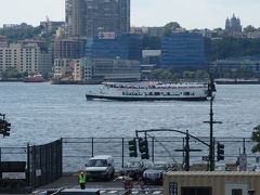
  • ハドソン川を行くサークルライン。

    ハドソン川を行くサークルライン。

    サークルラインクルーズ アクティビティ・乗り物体験

  • ヘリコプターによる観光。

    ヘリコプターによる観光。

  • ニュージャージの方。

    ニュージャージの方。

  • ハイラインにかざりつけがしてありました。

    ハイラインにかざりつけがしてありました。

  • いろいろな旗。

    いろいろな旗。

  • いろいろな色。

    いろいろな色。

  • 車両基地とベッセル。

    車両基地とベッセル。

  • 高いビル。

    高いビル。

  • 車両基地とベッセル。

    車両基地とベッセル。

  • すごい景色。

    すごい景色。

  • 対照がすごいですね。20世紀と21世紀。

    対照がすごいですね。20世紀と21世紀。

  • 小鳥も。

    小鳥も。

  • 不思議そう。

    不思議そう。

  • 青空。

    青空。

  • ベッセル。

    ベッセル。

  • 全景。

    全景。

  • 現代のにゅーよーく。

    現代のにゅーよーく。

  • 現代の景色です。

    現代の景色です。

  • 5番街とは違う。

    5番街とは違う。

  • 新しいニューヨーク。

    新しいニューヨーク。

  • これからの街です。

    これからの街です。

  • 車両基地はどうなるのでしょうか。

    車両基地はどうなるのでしょうか。

  • Penn Station は工事をしていましたね。

    Penn Station は工事をしていましたね。

  • ここはニューヨークの西の入口。

    ここはニューヨークの西の入口。

  • 現代的なビル。

    現代的なビル。

  • 北の突端にたどり着きました。

    北の突端にたどり着きました。

  • これでハイラインのお散歩は終了です。<br />ひとまず,ホテルに帰りましょう。

    これでハイラインのお散歩は終了です。
    ひとまず,ホテルに帰りましょう。

5いいね!

利用規約に違反している投稿は、報告する事ができます。 問題のある投稿を連絡する

コメントを投稿する前に

十分に確認の上、ご投稿ください。 コメントの内容は攻撃的ではなく、相手の気持ちに寄り添ったものになっていますか?

サイト共通ガイドライン(利用上のお願い)

報道機関・マスメディアの方へ 画像提供などに関するお問い合わせは、専用のお問い合わせフォームからお願いいたします。

nomonomoさんの関連旅行記

nomonomoさんの旅行記一覧

この旅行で行ったスポット

旅の計画・記録

マイルに交換できるフォートラベルポイントが貯まる
フォートラベルポイントって?

アメリカで使うWi-Fiはレンタルしましたか?

フォートラベル GLOBAL WiFiなら
アメリカ最安 288円/日~

  • 空港で受取・返却可能
  • お得なポイントがたまる

アメリカの料金プランを見る

フォートラベル公式LINE@

おすすめの旅行記や旬な旅行情報、お得なキャンペーン情報をお届けします!
QRコードが読み取れない場合はID「@4travel」で検索してください。

\その他の公式SNSはこちら/

この旅行記の地図

拡大する

PAGE TOP