
2025/09/06 - 2025/09/12
1320位(同エリア1626件中)
世界みりょく発見さん
- 世界みりょく発見さんTOP
- 旅行記22冊
- クチコミ2件
- Q&A回答4件
- 9,816アクセス
- フォロワー1人
コロラド川ラフティング7日間キャンプ :
7Day Motorized Rafting Trip in Grand Canyon
今日はすごく良い1日! グランドキャニオンの成り立ちがよく分かるダイナミックな地形の変化が楽しめました。地殻変動による断層が綺麗に見えて地球のエネルギーに感動!
Day3 : Today was a wonderful day.
Our Guide W gave us detailed instruction about the geiology along the river.
Thanks to that, I had a better experience than I expected.
Upper canyon is the best place to enjoy the formation of this valley and the beauty of each layer.
Choosing Full Canyon trip was a great decision for me!
- 旅行の満足度
- 5.0
- 観光
- 5.0
- 交通手段
- 船
-

Our moter trip “7 Day Full Canyon” started Lees Ferry (Mile0).
Our today’s camp site(Camp Trinity: Mile92) is just 4 miles downstream from the start point of Lower Canyon trip (Mile88).
If I had taken the Lower Canyon trip, I would have missed this section today. -
The yellow star marks are our campsite and start point (upper right).
Day1, 23mile trip : Kaibab formation to Supai Group ; Permian& Pennsylvanian(the younger part of the Carboniferous period)
Day2, 30miles: RedWall Limestone ~Bright Angel Shale[Tonto Group] ; Mississippian(the older part of the Carboniferous period &Camblian)
Day3(today) 40miles trip : Tepeat Limestone [Tonto Group]-GrandCanyon Super Group-Precambrian basement rock
How did the Grand Canyon form?
Next webpage explains the geological history well.
https://earthathome.org/quick-faqs/how-did-the-grand-canyon-form/
This is a image from the website. -
Image by Wade Greenberg-Brand, modified for the Earth@Home project.
Today's key layers and keywords are Tonto Group<Bright Angle Shale & Tepeat Sandstone>,Grand Canyon Super Group, Vishunu Basement Rock, Fault and Graet Unconformity. -
This is today’s route map.
The pink heart marks are the confluence of the Little Colorado and today’s afternoon side hiking spot.
The green flag marks are the Butte fault and the start point of the upper Granite Gorge (Remarkable Geological spots)
Day 3 Mile53 Main Nankoweap camp site
5:15AM. I woke up. I slept better than the previous day.
6:00 Coffee Call
French toast and bacon for breakfast.
8:00AM We start rafting again. -
Sky is clear.
On the way to the confluence of the Little Colorado river, I enjoyed the beautiful colors of the Bright Angel Shale layer of the Tonto Group.
You can see the photo of this layer on the next webpage.
https://alchetron.com/Bright-Angel-Shale
It was completely different from the Bright Angle Shale I saw from South Rim Village and the South Kaibab Trail. -
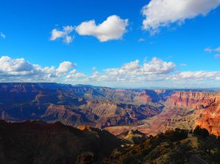
This is a photo I took from Yavapai Point in South Rim Village 5 days ago (Sep 3th).
You can see green Tonto Platform and the Vishnu Basement Rocks underneath it.
The Tonto Platform was formed by the erosion of the soft Bright Angel Shale, leaving a hard Tapeats Sandstone underneath.
The Tonto Trail and the Plateau Point are on the layer.
Erosion makes its color monotonous.
Geology Note, Mile 58
Tapeats Sandstone first appears -
9:30AM
Mile 62 : the confluence of the Little Colorado river
You can see that the color of the river water is clearly different on the left and right.
The muddy water on the left comes from the Little Colorado River. -
This photo was taken from Desert Viewpoint four days ago(Sep4th). You can see the muddy Colorado River.
Seeing this view, I imagined the Little Colorado River's water to be much muddier.
The water was less murky than I expected, but it wasn't a clear blue, so we didn't swim in it. -
We were on the Tapeats Sandstone by the Little Colorado River.
You can see the beautiful rock layers from Kaibab formation at the top of the distant rock wall to the Tapeats at ground level.
Let me explain about the Grand Canyon’s three different rock sequences .
1. Flat-lying strata
2. An inclined set of strata= Grand Canyon Super Group
3. Metamorphic and Igneous Rock.
Tapeats Sandstone is an oldest layer in Flat-Lying Strata.
At this point, it is possible to see all the layers of 1st Flat-lying strata.
So after this brief stop, we could see Grand Canyon Super Group’s unique landscapes.
Mile 63 Hopi salt mine
We could see white deposits in the lower layer of the rock wall on the left side.
Guide S told us about the story.
When Hopi men turned 13, they came here to collect salt.
A pilgrimage to these Grand Canyon salt mines was traditionally a rite of passage into adulthood
You can see a picture and read more about it in this website below.
https://www.nationalparksblog.com/tag/hopi-salt-mines/
Mile 63 right after enjoying Hopi-salt mine
Geology Note; Dox Sandstone first appears : Beginning of Unker Group (Grand Canyon Super Group)
Great Unconfirmity (between the Tapeats Sandstone) first appears.
Dox Sandstone is not a youngest layer in the Ground Canyon Supergroup.
It is one of five formations of Unkar Group of Grand Canyon Supergroup.
Overlies Shinumo Quartzite and underlies Cardenas Basalt.
Cardenas Basalt will appear later.
Grand Canyon Supergroup’s unique characteristics:
① Tilted about 20 degrees
② limited locations in Grand Canyon we can see
③ cannot all be seen in one view
Butte Fault (Carbon creek : Mile 65)
I never imagined I'd be able to see such a spectacular fault line.
I have no photos of Butte Fault.
The Facebook photo below shows a close up of the fold.
https://www.facebook.com/geologypage/posts/folding-grand-canyon-geology-geologypage-foldthe-fold-pictured-on-left-is-found-/879994437492116/
We could see these folded rocks from various angles.
This section was my most impressive part of this trip.
I felt the incredible energy of the earth!
The following video taken by a geologist provides a very clear explanation of the formation of the Butte Fault and the Grand Canyon.
https://www.youtube.com/watch?v=0yC5tc8KJoI -
This is a photo I took from the Desert View Watch Tower.
Wide spot in Canyon.
This section offers a wide view unlike any other in the canyon.
The open, rolling topography can be attributed to the soft, easily eroded Dox Sandstone outcrops that form the riverbanks.
You can see black Cardenas Basalt above Dox Sandstone and under Tapeats Sandstone(right=south side of the river)
Dox Sandstone first appeared at Mile63 and then Cardeanas Basalt appears above Dox Sandstone at mile66.
At the center of this photo is Lava Canyon Rapid at Mile 66.
Our Guide S took a textbook route over this Rapid.
A delta can be seen on the right bank of the Colorado River.
Mile 69 Tanner Rapid is at this Delta.
From here we could see a fantastic Butte Fault’s view again!
Another Facebook photo: Butte Fault viewed from the Colorado River from Tanner: Mile69
https://www.facebook.com/AZ.Geological.Survey/posts/grand-canyons-butte-fault-viewed-from-the-colorado-river-the-fault-was-first-act/812237044030497/
Geology Note : Nankoweap Formation first appears above black lava. -
Mile 72 : right before Unker Delta
11:00AM
You can see a series of tilted layers of stone known as the Grand Canon Supergroup.
The Supergroup is a complex collection of ancient sedimentary and igneous rocks ranging in age from 729 million to 1.255 billion years, the oldest sedimentary deposits in the canyon.
Though I couldn’t recognize from the river, we can see the Nankoweap Formation above black lava(Cardenas Basalt) ,underneath Tapeats Sandstone in the right of this photo. -
This is by Belnap’s waterproof Grand Canyon River Guide
-
11:50
Mile75 Upper Neville : We landed and had a lunch.
Mile75 Shinumo Quartzite first appears
https://www.youtube.com/watch?v=DpXl2wn4uFw -
12:30 afternoon’s hiking
Mile75 : 75mile creek
Shimno Quartzite’s rock walls both sides.
It was fun to walk along the way and see flash floods eroding the rock walls, and the mud and pebbles that the water carried from upstream remaining on the rock surfaces. -
12:50
Group photo at the turnaround point of the hike.
After Lunch and an afternoon hike, we started down the river again and enjoyed a lot of Rapids!
Mile 77 Hance Rapid
It’s dropping 30 degrees!!
If you look at this rapid from upstream, you can see that it is completely different from the previous rapids and descends at a steep angle.
It was really fun! -
13:40 Mile 78
Geology Note : Bass Formation, Hotauta Conglomerate,Vishnu Shist (black) and Zoroaster Granite (pink), first appear.
This is where Upper Granite Gorge begins.
The Upper Granite Gorge is the deepest, oldest, and most rugged section of the Grand Canyon, stretching about 41 miles from below Hance Rapid to Elves Chasm. -
This is a photo I took from Yavapai Point in South Rim Village.
You can see green Tonto Platform and the Vishnu Basement Rocks underneath it. You can also see a small part of the Colorado River at the bottom of the valley. -
14:00 Mile 79
Towering Vishnus rock cliffs.
We continued to descend, enjoying the rapids that appear one after the other, the magnificent scenery, and the beautiful rock faces, especially “fluted” Vishnu Shist.
Fluting is a process of differential weathering and erosion by which an exposed well-jointed coarse-grained rock such as granite, gneiss or vishnu schist develops a corrugated surface of flutes.
Because the rock in the gorge does not easily erode, the river becomes swifter and the rapids grow larger.
Mile 88 Kaibab Suspension Bridge (1928)
Bright Angle Bridge (1970)
We passed bridges around 15 o’clock.
The canyon was so deep that the river was already in the shadow.
We landed on our today’s campsite around 16 o’clock.
Mile 92 : Trinity Creek (2375 feet above sea level )
Today we went 40 miles(65km) and descended 380 feet(116m). -
17:00
Maybe because the altitude has dropped, it's still hot in the sun.
A strong wind blew from the river at times, and the tent we had set up was in danger of being blown away, so we decided to spend without a tent today. -
I relaxed on a shady rock for a while, writing in my diary and reading a book with some snacks.
As the name of the campsite suggests, I could enter at the entrance to Trinity Creek.
Surrounded by Vishnu basement rocks, I was able to feel the power of the earth. -
18:00
Our tour guides were cooking dinner for us.
The water in the river wasn't too muddy so I took bath in it. -
18:30
Today’s dinner contained a lot of vegetables and was delicious!!

![The yellow star marks are our campsite and start point (upper right).<br /><br />Day1, 23mile trip : Kaibab formation to Supai Group ; Permian& Pennsylvanian(the younger part of the Carboniferous period) <br />Day2, 30miles: RedWall Limestone ~Bright Angel Shale[Tonto Group] ; Mississippian(the older part of the Carboniferous period &Camblian)<br /> Day3(today) 40miles trip : Tepeat Limestone [Tonto Group]-GrandCanyon Super Group-Precambrian basement rock<br /><br />How did the Grand Canyon form?<br />Next webpage explains the geological history well.<br />https://earthathome.org/quick-faqs/how-did-the-grand-canyon-form/<br /><br />This is a image from the website.](https://cdn.4travel.jp/img/tcs/t/pict/src/88/69/31/src_88693137.jpg?1767068955)


この旅行記のタグ


利用規約に違反している投稿は、報告する事ができます。
旅行記グループ
グランドキャニオン ラフティング川下り7日間
-
前の旅行記

Redwall Cavernで化石&Puebloan granaries 穀倉庫の遺跡 Day2: Raft...
2025/09/06~
グランドキャニオン周辺
-
次の旅行記

Shinumo Creek & Elves Chasm : Day4 Grand Canyon Raftin...
2025/09/06~
グランドキャニオン周辺
-

ページからコロラド川ラフティングツアーに出発 1st Day: Grand Canyon Rafting R...
2025/09/06~
ページ
-

Redwall Cavernで化石&Puebloan granaries 穀倉庫の遺跡 Day2: Raft...
2025/09/06~
グランドキャニオン周辺
-

Little Colorado & Upper Granite Gorge : Grand Canyon R...
2025/09/06~
グランドキャニオン周辺
-

Shinumo Creek & Elves Chasm : Day4 Grand Canyon Raftin...
2025/09/06~
グランドキャニオン周辺
コメントを投稿する前に
十分に確認の上、ご投稿ください。 コメントの内容は攻撃的ではなく、相手の気持ちに寄り添ったものになっていますか?
サイト共通ガイドライン(利用上のお願い)報道機関・マスメディアの方へ 画像提供などに関するお問い合わせは、専用のお問い合わせフォームからお願いいたします。
グランドキャニオン周辺(アメリカ) の旅行記


グランドキャニオン周辺(アメリカ) の人気ホテル


フォートラベル公式LINE@

おすすめの旅行記や旬な旅行情報、お得なキャンペーン情報をお届けします!
QRコードが読み取れない場合はID「@4travel」で検索してください。
\その他の公式SNSはこちら/


旅行記グループ グランドキャニオン ラフティング川下り7日間
0
22