
2008/09/17 - 2008/09/17
213位(同エリア525件中)
![]()
いぶれすさん
何年か前のNHKhiで女優の石田えりさんとシャモニーの日本語観光案内係のベルナデットさんがトゥール・ドゥ・モン・ブランのコースを歩く番組が放映されましたが、その中で、ちょっとコースを離れてグラン・サン・ベルナール峠付近を登るシーンがありました。登った場所についての言及はありませんでしたが、峠の西にある湖の位置から峠の北に登ったことは分かりました。
テレビでは、景色が大変良さそうでしたので、この頂に見当をつけて登ることにしました。
登ってみると、テレビで放映されたゴール地点は、この頂の鞍部にあるちょっとした展望台でした。
ここからでも見える景色は頂上からと大して変りませんし、頂上へは、梯子、フィックスト・ワイア・ロープ、鎖の連続で肝を冷やしましたので、露出箇所や高度感が特にお好きな方以外は、展望台で止めておくのが正解だと思います。
尤も、先行グループは、あっという間に正面のポワント・ドゥ・ドゥローヌの頂に立っていましたが。
It was entirely a TV program of NHK(national broadcast station) I enjoyed some years ago that motivated me to climb up this mountain.
Bernadette-san, very famous and popular among Japanese tourists who visited Chamonix-Montblanc and known even by those who never visited the tourist office she works for, as she is known to be so kind to offer a helping hand to every tourist who is in trouble wherever or whenever she is with, was a principal figure together with a Japanese actress named Ishida.
B.t.w., I was not an exception to have had an honor to chat with her. She spoke to me from my back in fluent Japanese probably after her luncheon break causing me a natural surprise at looking her back after I had finished my business at the tourist office.
They made the TMB, or a part of it with additions of walking on the glacier from Helbronner to Aiguille du Midi and a hiking around Col du Grand St. Bernard.
And this is it.
Although they did not tell where it exactly was, they called it summit. So, I figured it out on the map based on the location of the lake near the pass.
Their goal turned out to be a sort of shoulder instead of summit. With a short hesitation by fear, I decided to go for the summit of this Grande Chenalette mostly because I had told so to a Japanese friend who happened to take the same bus, and departed at the pass after taking a souvenir photograph.
It was too much for me. Ladder, fixed wire rope, chains I had to completely rely on to climb, etc. And yet, the view from summit remained almost the same as the one from shoulder, of course, apart from a sense of accomplishmenet.(descriptions in English added on 23/07/2011)
-

アクセス: トンネルではなくグランサンベルナール峠に向かうバスの終点より。大抵はオルシエール発。
-
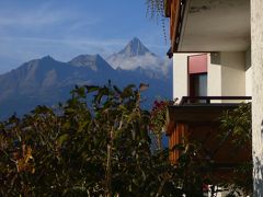
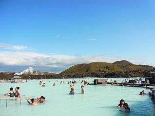
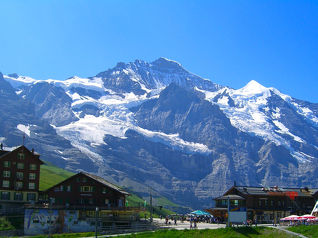
まずは、グラン・サン・ベルナール峠から仰ぎ見る。一番高くみえる所が目指すグランド・シュナレット頂上。
-
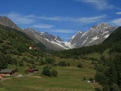
30分も登るとこんな景色になります。左はスイス側の救護所。右の建物はイタリアにあります。
-
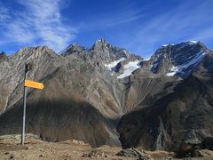
1時間強でその展望台に達します。まずは、北側に聳えるグラン・コンバン(左)とモン・ヴェラン
-
南のイタリア側。右奥に覗くのは、モン・ブランとグランド・ジョラス
-
モン・ブランとグランド・ジョラスのズーム・ショット
-
正面は、頂上に人影がみえるポワント・ドゥ・ドゥローヌ。左右の高峰は、モン・ドランとトゥール・ノワールでしょうか。
-
頂上の標高は2,890Mの筈ですが、赤いペンキで派手に2,900Mと書かれていました。
-
頂上よりグラン・サン・ベルナール峠を見下ろして。 湖の右下に見えるコンクリートの平地が展望台です。
-
下山の際、梯子を覗いたところ。あまり怖そうには見えませんが。
-
鞍部まで戻ってグランド・シュナレットの全容を振り返る。
-
グラン・コンバンとモン・ヴェランのアップをもう一度


この旅行記のタグ


利用規約に違反している投稿は、報告する事ができます。
コメントを投稿する前に
十分に確認の上、ご投稿ください。 コメントの内容は攻撃的ではなく、相手の気持ちに寄り添ったものになっていますか?
サイト共通ガイドライン(利用上のお願い)報道機関・マスメディアの方へ 画像提供などに関するお問い合わせは、専用のお問い合わせフォームからお願いいたします。
その他の観光地(スイス) の旅行記

その他の観光地(スイス) の人気ホテル


フォートラベル公式LINE@

おすすめの旅行記や旬な旅行情報、お得なキャンペーン情報をお届けします!
QRコードが読み取れない場合はID「@4travel」で検索してください。
\その他の公式SNSはこちら/

0
12