
2011/05/15 - 2011/05/19
2924位(同エリア3667件中)
![]()
healthyaさん
- healthyaさんTOP
- 旅行記54冊
- クチコミ12件
- Q&A回答1件
- 210,023アクセス
- フォロワー0人
昨年のゴールドコースト旅行では「ミントン国立公園 スプリングブルック国立公園」のエコツアーに参加した時はガイドさんについて行くのが精一杯で、
「ゆっくり見たいな〜」「前もって見るポイントが分っていればな〜」
という気持ちから、解説の看板を見る度に撮影しました。
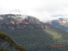
今回はシドニーのブルーマウンテンのシーニックワールドの谷底編です。
現地では、韓国、日本、中国からの修学旅行生や観光客の多い中、ゆっくり撮影ができず、モチロン、全て撮影できたわけではありませんが、前もって調べておきたい方のお役に立てればと思います。
現地では日本語で解説している看板は無かったと思いますので、この旅行記にある看板の内容を把握して現地に行くと充実度が全然違うと思います。
旅行から2年以上経ってますが、思い出した時にテキスト化していますので、かなり時間がかかるかもしれません。
- 旅行の満足度
- 4.5
- 観光
- 5.0
- グルメ
- 3.5
- ショッピング
- 3.5
- 同行者
- 友人
- 一人あたり費用
- 10万円 - 15万円
- 交通手段
- 鉄道 観光バス
- 航空会社
- ジェットスター航空
- 旅行の手配内容
- 個別手配
-

The Mountain Devil
This is a replica of the original "Mountain Devil" Scenic Railway car.
The original car was built by the Katoomba Coal Mine to replace the coal skip which had been used for passenger transport at weekends.
This was to satisfy the growing demand from bushwalkers and tourists seeking a more comfortable ride to and from the valley.
You are velcome to climb aboard for a photo opportunity. -
-
Scenic Railway Facts
Length:415 metres
vertical Drop:206 metres
Steepest Inline:52 degrees
Length of Natural Tunnel:60?metres -
Katoomba Coal Mine 1878
This furnace was used to draw air through the mine to the work face.
The air was directed to the miners by use of baffles made of wood or hessian.
どうして火を焚くことで空気を引き込めるのか・・・私にはわからないけど。 -
Extract from 1908 Geology Report
Blue mountains AUSTRALIA
DEPARTMENT OF MINES AND AGRICULTURE
MEMOIKS OF THE GEOLOGICAL SURVEY OF- NEW SOUTH WALES
EF PITMAN ARSM.UNDER SECRETARY AND GOVERMENT GEOLOGIST
GEOLOCY, No. 6.
GEOLOGY AND MINERAL RESOURCES OF THE WESTERN COALFIELD
WITH MAPS AND SECTIONS BY J.E.CARNE, F.G.S ASSISTANT GOVERNMENT GEOLOGIST
ISSUED BY DIRECTION OF THE HON. JOHN PERRY, MP MINISTER FOR MINES AND AGRICULTURE
SYDNEY;WILLAM APPLEGATE GULLIK, GOVERMENT PRINTER -
171
Description of Coal-seams.
No,1.Top or "Katoomba" Seam opened at Katoomba by Mr.J B. North 1878 Colliery started in 1882 (17 on plan of Wostrrn Coal-field).
Opened by tunnel under plateau escarpment about eight hundred feet below the Great Western Kailwav at Katoomha, and six hundred and twenty five feet below top of vertical criffs at the engine bank.
When at work, the coal was conveyed to the railway by an incline and endless tramway cable two miles in length.
Northerly and easterly the workable coal things considerably,but maintains a workable thickness to north,west and south-west.
Thickness and quality of south-west face ore shown in the following section and
Fig 25 -
Dual Tramway
This section of the tramway was photographed in 1892.
At this stage 154 men worked'at the various mines in the area and they extracted 22,000 tonnes of shale during the course of the year.
The cliff in the background of this picture is now the famous Katoomba Landslide.
This particular section of tramway ran between the Mount Rennie tunnel through Narrow Neck, and thhe Daylight Tunnel through the old Katoomba coal mine.
The skips visible here carried oil shale from the Glen shale mine in the Megalong Valley to the base of the incline,which is now the Scenic Railway. -
Formation of Three Sisters
Erosion tends to follow planes of weakness
called joints.
These joints occur here in vertical sets, and give the cliff lines the blocky straight edged appearance.
With progressive erosion, great blocks of sandstone fall into the valleys, breaking off at the joints.
These large blocks can be seen at the bottom of the cliffs.
Often large pillar like
structures such as the Three Sisters and
Orphan Rock are left standing.
Eventually even these are worn away so that all that remains is a pile of rubble like the Ruined Castle and, in time, even such hills as this are removed.
Along the spur beyond the Three Sisters can be seen a series of four stumps,suggesting that there may once have been Seven Sisters, although presumably the present three would at that time have been less separated than now. -
Below the Katoomba Seam
It is obvious to any visitor that the terrain below the Katoomba Seam is very different from the spectacular Triassic sandstone cliffs above the seam.
Below the seam are relatively gentle slopes covered with eucalypts and rainforest.
There are no cliffs and few outcrops of rock,
although there are numerous huge blocks ofsandstone, which have come crashing down from the cliffs over geological time.
The reason for the relatively gentle terrain below the Katoomba Seam is that over time the falling of the rocks and resulting downhill movement of fine particles and other matter forrhed the Talus Slope.
Harder layers underlay this Talus slope.
The Talus became the basis for the soil that now
provides the nutrients to the rainforest. -
Formation of Geological Landmarks
Erosion tends to follow planes of weakness called joints.
These joints occur here in vertical sets, and give the cliff lines the blocked straight edge appearance.
With progressive erosion, great blocks of sandstone fall into the valleys breaking off at the joints.
These large blocks can be seen at the bottom of the cliffs, often large pillar like structures such as the Three Sisters and Orphan Rock are left standing.
Eventually even these are worn away so all that remains is a pile of rubble like the Ruined Castle and in time even such hills as these are removed.
Along the spur beyond the Three Sisters can be seen a series of four stumps, suggesting that there may once have been Seven Sisters, although presumably the present three would at that time have been less separated than now -
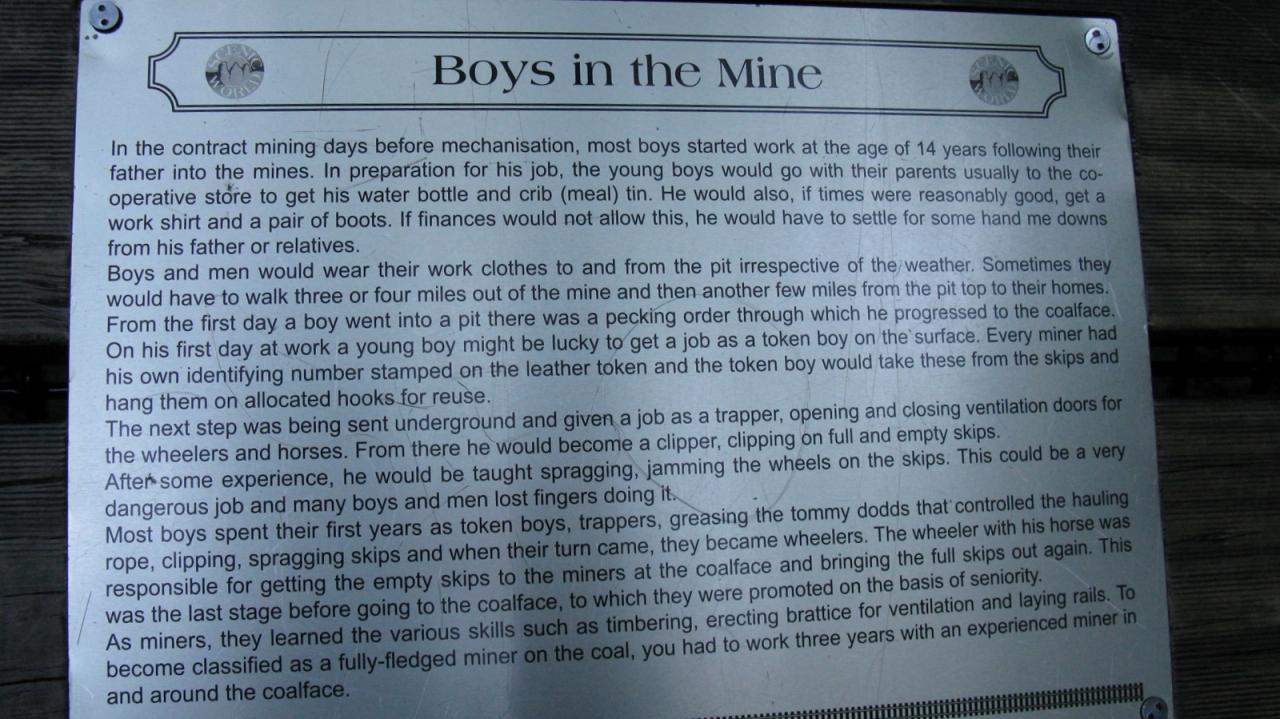
Boys in the Mine
男子は14歳から父親と鉱山で働いていたようだ。
一人前になるには熟練工の下で3年(以外に少ないな)。
token boyからスタートして trapperやclipperなどを経て
wheelerになって鉱夫との間でスキップとよばれる石炭を入れるコンテナを馬で運ぶ。
In the contract mining days before mechanisation, most boys started work at the age of 14 years following their father into the mines.
In preparation for his job, the young boys would go with their parents usually to the cooperative store to get his water bottle and crib (meal) tin.
He would also, if times were reasonably good, get a work shirt and a pair of boots.
If finances would not allow this, he would have to settle for some hand me downs from his father or relatives.
Boys and men would wear their work clothes to and from the pit irrespective of the weather.
Sometimes they would have to walk three or four miles out of the mine and then another few miles from the pit top to their homes.
From the first day a boy went into a pit there was a pecking order through which he progressed to the coalface.
On his first day at work a young boy might be lucky to get a job as a token boy on the surface.
Every miner had his own identifying number stamped on the leather token and the token boy would take these from the skips and hang them on allocated hooks for reuse.
The next step was being sent underground and given a job as a trapper, opening and closing ventilation doors for the wheelers and horses.
From there he would become a clipper, clipping on full and empty skips.
After some experience, he would be taught spragging, jamming the wheels on the skips.
This could be a very dangerous iob and many boys and men lost fingers doing it.
Most boys spent their first years as token boys, trappers, greasing the tommy dodds that controlled the hauling rope, clipping, spragging skips and when their turn came, they became wheelers.
The wheeler with his horse was responsible for getting the empty skips to the miners at the coalface and bringing the full skips out again.
This was the last stage before going to the coalface, to which they were promoted on the basis of seniority.
As miners, they learned the various skills such as timbering, erecting brattice for ventilation and laying rails.
To become classified as a fully-fledged miner on the coal, you had to work three years with an experienced miner in and around the coalface. -
John Britty North
(The Father of Katoomba)
A man on the lookout for opportunities and having a mining background was John Britty North.
He purchased 640 acres from Captain Robert Henry Reynolds and eventually additional land as a mining conditional purchase.
In 1878 he initiated exploratory adits in the coal seam below the Orphan Rock (where you are standing) in the Jamison Valley, utilising a natural tunnel in the edge of the escarpment.
He enlarged it to provide a route for a steam driven dual incline haulage, to provide access to the coal seam 219 metres below the dliff top.
It took some years to raise the necessary capital and install the equipment needed, but by 1883 the mine was in full production.
A double incline had been constructed up from the base of a small self acting incline which brought the coal down about 40.metres from the mouth of the adit to the base of the main incline.
At the top of the main incline a dual tramway was constructed covering the 3 kilometres to a railway siding on the main western line.
By 1888 there were 23 men employed underground and 60 men on the surface, the total output for the six months June to December being 65,680 tons of coal. -
The Miner and the Pony
One of the most moving features of coal mining in the 1800's is the relationship between the miners and the pit ponies.
The miners had a wonderful respect for the ponies whom they considered to be work mates and knew them all by name.
They would not tolerate anyone in the pit who abused them.
They admired the strength and intelligence of the ponies and recognised the distinct personality of each one.
They shared the laughter and delight in incidents which pitted stubborn miners against smart ponies.
To the miners, ponies were not beasts of burden; they were valued work mates whose injuries and deaths were genuinely mourned. -
Katoomba Incline Railway
The incline railway, designed by Sydney civil engineer,
Norman Selfe, was initially built with twin tracks and was
completed in 1882. It passed through a natural tunnel in a
slot existing in the cliff face between Orphan Rock and the
present site of the tourist centre. A substantial amount of
rock blasting was necessary to provide a uniform grade
(average of 44°) from the cliff top 200m down to the valley
some 30m below the outcrop of the Katoomba seam.
Travellers on the Scenic Railway, the world's steepest
funicular railway, pass down through, and alongside,
sandstone and shale of the Triassic period (between 250
and 205 million years ago) and down to the coal seams
and more shale and sandstone of the Permian Period
(300 to 250 million years ago). These rocks are all older
than the time of the dinosaurs, which was the Jurassic
Period. -
Coal from Mine to Railway
This is a photograph of the Katoomba colliery incline
taken on November 5 1884. During this time the colliery
employed 56 men who extracted approximately 20,000
tonnes of coal in that year.
The coal skips being loaded in the bottomright hand
corner of the picture are about to be hauled up one of the
two tracks to the top of the incline before transferal to the
tramway. A tramway of similar design to the one in the
next picture then took the coal a further 2km to the
railway siding at Katoomba. The coal was then loaded
into railway trucks for the journey to Sydney. -
Torbanite (Oil Shale)
Coal is formed from the accumulation, compression and alteration of plant matter over a long period of time.
However, between about 60 mtrs and 80 mtrs below the Katoomba Seam are seams of another coal-like material, not formed from plant matter but from a great thickness of algae.
This amazing material, which looks like a modern plastic, is called Torbanite, or more commonly oil-shale.
In the area below the Katoomba Colliery workings, the Torbanite, which frequently occurred in lens like deposits, was not thick enough or of good enough quality to be mined.
However, about 3 Kms to the southwest,beneath the Narrow Neck peninsula, was mined some of the richest Torbanite found anywhere in the world, producing up to 500 litres of kerosene oil per ton of shale.
Pieces of Torbanite are scattered all over the hillside below the mine site, because the material mined beneath the Narrow Neck peninsula between about 1888 and 1897, was transported to the top of the escarpment via the incline (Scenic Railway).
The material was then carried to the Great Western Railway at, what is now known as, Shell Corner. -
Landscape & Geology
The Blue Mountains are the remnants of an
enormous plateau that has been eroded by
rivers and creeks.
The rock strata that make up the plateau were
laid down approximately 250 million years ago,
primarily as layers of sand and silt and the
remains of plants in a vast bay identified as the
"Sydney Basin". The rivers flowing into the basin
gradually filled it with sediment pushing the sea
eastward and creating deltas and swamps.
Between 90 and 35 million years ago a
geological uplift raised the basin to create a
plateau.The rivers and creeks continued to
grind down arid left exposed, the sediment,
which was now compressed and turned to rock,
mainly sandstone. -
The Coal Railway
The incline (Scenic Railway) was built in the early 1880's to convey coal to the cliff top from a mine in the Katoomba Seam.
This outcrops just below the base of the sandstone cliffs that are such a distinctive feature of the Blue Mountains.
The coal mine was established by John Britty North who arrived in Katoomba sometime in the early 1870's.
In 1878 he registered the company The Katoomba Coal Mine. One of his first ventures was to extract an approximately 200 kg block of coal, have it man-handled up the 200m high escarpment,and then displayed at the 1879 International Exhibition in Sydney.
Based on sample it is believed he was awarded a Government contract to supply coal to the NSW Railways. -
The Katoomba Mines
From North's Siding (near Shell Corner) the dual track cable tramway descended, undulating, to the "engine bank", now the top of the Scenic Railway.
Two bridges were crossed; the first a suspension bridge, the cables of which were anchored to trees, the second was a wooden trestle.
From the engine bank it plunges into a rock tunnel,emerging on the talus slope of the valley, and continuing steeply down to the terminus near the old Katoomba Coal Mine.
From the coal mine, a second dual track cable tramway passed through the Daylight tunnel under Malatia Point, then two small tunnels before crossing a trestle bridge.
It came to a junction with the horse drawn, tramway to the Ruined Castle mines.
The cable line continued through the Mount Rennie tunnel under Narrow Neck, and into the Megalong Valley to the Mart's Glen shale mine.
The mine tunnels were connected by a line, probably horse drawn, which ted into a gravity powered incline.
This in turn connected with the cable railway. -
KATOOMBA COAL MINE ARTIFACTS
CIRCA 1898
1 MINER S COAL SHOVEL
2 MINER'S SHORT HANDLED' WORK PICK
3 MINER'S ALL PURPOSE' CROW BAR
4 MINER S COAL FORK
5 ORIGINAL HAULAGE TRACK ROPE
6 MINER'S RABBIT TRAP
7 PIT PONY SHOES
8 MINER'S GREASY POT LIGHT
9 MINER S HAND BORE
10 HAND BORE WINDER
11 MINER S SHORT HANDLED WORK HAMMER
12 15 INCH 1 3/8 TWIST DRILL
13 12 INCH 1 7/8 TWIST DRILL
14 36 INCH 1 7/8 TWIST DRILL
15 27 INCH 1 3/4 TWIST DRILL
16 MINER'S HAND SAW
17 COAL SKIP WHEEL SPRAG
18 RAILWAY SPIKE
19 TOMMY DODD' HAULAGE ROLLER
20 METAL FILE USED FOR PONY SHOEING -
左
SCENISCENDER
BOTTOM
STATION
右
LANDSLIDE
GOLDEN STAIRS
RUINED CASTLE -
4s you will, see, wind and lightning are the greatest enemies of the trees in this rainforest.
This vine intertwines with most of the canopy of this temperate rainforest.
It serves to strengthen the canopy as a whole and protect it from wind damage, as it ties the tops of the individual trees together to provide a uniform front and a stronger combination than individual trees can provide.
Rainforest in the Blue Mountains only occurs where there
is protection from drying westerly winds.
Below the high cliffs and in the deep canyons grow specialised trees and plants.
Plants in the rainforest have greener, softer leaves than
those of the dry forest on the ridgetops, and enjoy a steady supply of water available in the soil.
Tall trees limit the amount of light available to grow plants
on the forest floor.
Specialised plants like the water vine solve this problem by winding around and climbing the trees to grow their leaves in the canopy. -
Prickly Currant Bush
(Coprosma quadrifida)
This shrub is not common the Blue Mountains.
The male & female flowers are borne on separate plants.
It has round red fruits in December - January. -
Sassafras(Doryphora sassafras)
If You stand on the cross on the boardwalk and place your eye in exactly the right place, yon can see a tiny sliver of light passing right through the middle of the trunk of this tree.
Doryphora sassafras is one of the dominant species in Blue Mountains rainforest.
The leaves are coarsely toothed and flowers are white star shapes in clusters of three.
Both the leaves and bark smell strongly. -
Five Leaf Water Vine
(Cissus hypoglauca)
Look around yon!
This is the vine system that supplies the foliage high up in the canopy with water and nutrients.
These vines are very strong.
One strand 20mm in diameter will support a family car. -
Coachwood(Ceratopetalum apetalum)
Coachwoods are easily recognised by their distinctive bark-pale grey with dark concentric rings.
If the trunk is exposed to direct sunlight it may show pink clothing.
Coachwood flowers are tiny,surrounded by special reddich leaves called sepals.
Tere are no petals.
During the early 1800s coachwoods were milled for their timber,many of the rifle stocks manufactured at the Small Arms Factory in Lithgow were made of local coachwood.
On the far side is a separate tree that sprouted in a crack and has grown to became a branch of the mother tree.
This tree is 4 meters in circumference and is 30 metres high(nealy 100 feet)
It was probably a sapling in 1501AD.
写真がボケボケでテキスト化には自信が無いですが・・・ -
Rough Tree Fern(Cyathea australis)
Ferns have no seeds - but they do have other reproductive structures.
At certain times of the year small brown areas develop on the underside of the fronds. These small
capsules contain large numbers of tiny spores, and when they are ripe, they open and release the spores
into the air. Spores are microscopic and simpler than seeds : many are no more than a single cell with a
wall around it. There is no embryonic plant inside.
When spores fall into a moist shady place, they germinate to form a flat little plant barely one centimetre across.
This is called the prothallus.
It does not even look like a fern until it germinates itself by producing its own sex cells or gametes. This is called a gametophyte.
Tree ferns are unusual because they have a stout vertical trunk which actually gets wider towards the top.
They grow soft fronds which unroll from the top. Aboriginals would eat this soft fern centre as a good supply of starch.
Look left!
This offcut from a gumtree highlights the tree rings showing that this tree was 50 years old when it fell. -
Rough Tree Fern(Cyathea australis)
This species of tree fern can grow to 12 metres high, with
fronds 4.5 metres long.
Monty measured this specimen by laser on April 1st, 2001.
It is 10.62 metres high! The tallest in the Jamison Valley.
Tree ferns are one of the oldest species of plants on earth.
This specimen is approximately 250 years old.
Cyatheas probably originated in GONDWANA, the great
Southern Continent formed by Australia, Africa and Antarctica.
Cyatheas are only found in the Southern Hemisphere. -
This tree fern is very unusual in that it has fallen over then regrown vertically.
Look Down!
Tree ferns have an unusual structure.
The trunk is covered in the adventitous root system of the plant, which can become active if they come in contact with soil.
Notice how the rootlets are facing down on the fallen over section of the trunk. The growing node of the plant is at the centre of the fronds. -
Popeway Buckets
Look right!
See how many buckets
you can see lying on
the forest floor.
During the six months that it was operating, these buckets fell
from the material ropeway that was built in 1889 to transport
shale 3.4 km from the Ruin Castle shale mines to Katoomba.
There were 47 wooden towers supporting the ropeway.
Each bucket carried about 50 kg of shale, the system worked
something like a modern detachable gondola ski lift.
In December of 1890 the return cable broke and made the
ropeway useless. Some of these buckets were salvaged from
the valley and sold in Katoomba to be used as water troughs
for horses.
Oil shale (Torbanite) is a greasy rock that is heated to produce
many distillates similar to crude oil. The main product was
kerosene or paraffin which was used for lighting.
Oil shale was mined at Ruin Castle, Megalong, Hartley and at
Newnes, north of Lithgow. The ruins of the oil shale works at
Newnes are preserved in Wollemi National Park. -
Sassafras and LilliPilli
Look left!
Sassfras (Doryphora sassafras ) and Lilli Pilli (Acmena smithii)
These two trees demonstrate how two quite different trees can evolve to
occupy exactly the same niche in the environment, grow at the same rate,
and gain mutual support from qrowinq so closely together. -
Slingshop Rock
This rock is aimed at one of the
'Three Sisters'.
Is the water vine strong enough?
Look left!
This Coachwood has had
a very hard life and been
knocked down probably by
other falling trees and then
regrown.
The rainforest's tenacity
for life is well
demonstrated here.
Look right!
The cliffs above are forever changing.
In winter, water freezes in the cracks of the rocks.
The cracks expand under pressure from'the ice and
rockfalls may result. The rectangular jointing of the
sandstone can also result in massive landslides.
This rock has probably been resting here for thousands
of years. The pockets around the rocks collect fallen
leaves and debris, which as decomposing bio-mass,
enriches the soil and allows the rainforest to grow
and recycle itself. -
Cedar wattle
This species grows very quickly and reaches 20 metres in height.
Like most Acacias it is short lived, abbut 20-30 years.
Look up!
The tallest growing of all the wattles, Acacia elata is also prone to wood boring insects and gall attack.
Profuse flowering by the tree in spring often carpets the ground underneath with pale creamy flowers.
Cedar Wattle forms large seed pods 14cm. long.
Acacias are pioneering plants, and will take advantage of any extra light that penetrates a gap in the canopy created by a fallen tree.
They form special bacterial associations in their roots that helps fix nitrogen (a vital plant food that promotes green growth) into the soil, not just for itself but for other plants too. -
Lyrebirds
Listen!
The loudest birdcall you mill hear in this forest is the Superb lyrebird- Menura novaehollandaie
You might hear a long song made up of fragments of many other bird calls.
When Lyrebirds mimic (copy) other birds, they will join the songs together to form a complex call Each male Lyrebird will stand upon his display mound and call incessantly, to attract a mate.
Lyrebirds nest in low forks of trees and around rocks at the basest cliffs.
Look!
lyrebirds help shape mountains!
Strange as this may seem, their constant scratching in the leaf litter moves up to a kilo of soil and rocks - always downhill.
An adult Lyrebird can move many tonnes of rock and soil in its lifetime.
Small birds, especially yellow robins and scrub wrens, follow Lyrebirds around when they are scratching to pick up the insects they miss. -
Surrender of Die!
Look left!
Each plant grows with an inbuilt drive to
survive and reproduce. Where the
watervine here has wrapped around the
coachwood, each struggles to outgrow
the other.
The tree is responding to the irritation of
the watervine by growing new tissue.
The watervine will continue to thicken and
may eventually strangle the tree.
Which do yon think will live longest? -
Biodiversity
The Web of Life
Any bare surface is first colonised by single celled plants called algae.
These are visible on the rock surface as red or yellow staining.
Once these establish, specialised plants called lichens (made of fungus and algae)start to grow.
These are greenish and grey.
Lichens produce acids in their rootlets which break up the sandstone.
As the lichen grows it catches dust and soil, which when wet allows the
mosses to grow.
Mosses accumulate more soil, and keep it wet,which further breaks up the rock.
Other plants grow in the soil accumulated by the mosses.
Grasses and small shrubs send their roots into the cracks and expand them.
Other plants grow on the rocks, including orchids and ferns.
The ancient sandstones of the Blue Mountains are being attacked!- even by the plants that rely on them to grow.
How many different plants can you count in this small garden of delights? -
Lightning!
Look up!
Lightning has killed this Lilli Pilli, by setting fire to its core.
The fire has weakened the base of the tree and cut off its
sap supply.
It is being held up by the live Coachwood beside it. -
What's the weather doing?
The habitats of the Blue Mountains are exposed to a large variety of weather patterns.
They range from cool mist and drizzle, through balmy mild days, to searing heat and desiccating winds, occasional snow and frequent summer thunderstorms.
Thunderstorms are often accompanied by fierce wind gusts and lightning strikes which can damage the larger trees. -
Erosion of the Sydney Basin
Only a few million years ago were the rocks of the Blue Mountains lifted up to form a plateau.
The lapstone monocline and Kurrajong fault were produced during this uplift.
Streams formerly flowing seawards along a gradual
gradient now plunged dramatically over the edge of the mountains.
As you walk through the rainforest you will observe the large sandstone blocks.
These fell from the cliffs approximately 10,000 years ago. -
Scenic Railway
There are nearly 100 kilometres of tunnels in the cliffs at the level where you are standing.
Coal mining began in this area in 1878. There were abou 40 mines at various times.
The railway you see above you was used to haul the coal up the cliff and it was then transported to Katoomba.
The last mine closed in the late 1930s.
Today the railway transports passengers instead of coal.
Portion of mine plan -
Rock Formations
The present landform
--------------------------
For millions of years the mountain streams have cut
through the upper layers of sandstone, following vertical
faults in the strata. The once vast plain has been
reshaped by water, as it slowly carries away the sand
that the mountains are made of.
The softer claystone layers in the middle and the shale
and coal layers at the bottom of the cliffs, are more
easily eroded.
As these softer layers are eroded, unsupported sections
of cliff face will collapse. This leaves the characteristic
vertical cliffs of the upper mountains・
Even now the valleys are widening very slowly, as
landslides and rock-fall shape the cliffs.
----------------
1番目→
softer claystone in the middle of the cliff
二番目→
shale and coal layers at the bottom are more easily eroded -
[FIRE TOWER]
Sharp-eyed viewers may be ableto see the bushfire spotters'tower on Narrowneck Plateau.
----------
[OLD TRAMWAY TRACK]
The walking track to the Ruined Castle is accessible via the Golden Stairs, and follows the nineteenth century oil-shale miners' tramway track.
---------------
[JENOLAN CAVES]
The lenolan Caves (28 km away) form part of the south western boundary of the Greater Blue Mountains World Heritage area and the end of the journey of Gurangatch and MIrragan.
-----------------
[MALAITA POINT]
A major landslide occurred on the western side of this ridge in 1931. The ridge was named after the birthplace of a Solomon Islander who once lived there.
-------------
[SCENIC WORLD]
The Scenic Railway and Scenlscender rides at the Scenic Railway Complex provide easy access into the jamison Valley. -
Prince Henry Cliff Walk
NSW NATIONAL PARKS AND WILDLIFE SERVICE
To Katoomba Falls Time: about 1 hour (one way)
Grade: Medium Kedumba
View to Katoomba Falls
Wheelchair access to
Kedumba View Lookout
Follow the sealed pathway to Kedumba View Lookout.
Continue along the track past Wollumai Lookout to Cliff View Lookout.
From Cliff View Lookout the track is again sealed for wheelchair access from Katoomba Park near Katoomba Cascades.
Cross Katoomba Cascades to reach the Watchtower and Duke and Duchess of York Lookouts above Katoomba Falls.
The best views of the fails are from Reids Plateau, a further 200m past the Watchtower.
To Scenic World
Grade: Medium
Time: about 1 hour (one way)
Follow Prince Henry Cliff Walk as above, to Katoomba Falls.
Go past Reids Plateau, up the steps and continue on Prince Henry Cliff Walk to reach Scenicworld.
Buses are available at Scenicworld to return to Echo Point or Katoomba. Phone 1800 801577 for bus timetable information.
Prince Henry Cliff Walk
Prince Henry Cliff Walk is named for Prince Henry, Duke of Gloucester, and was opened with that name in 1934.
Construction of the track linked other shorter tracks;
some constructed since the 1880s, and gave access to around 20 other tracks and numerous lookouts.
The track follows the cliff top from Scenicworld to Leura Cascades then on to Gordon Falls (not shown in picture).
Federal Pass
Federal Pass was constructed in 1900 and paid for by public subscription.
It was opened open the 3rd November 1900, by NSW Premier Lyne, and there were 17 Members of Parliament present.
The following year Federation of the States of Australia occurred.
Federal Pass connects Leura Forest with the bottom of the Giant Stairway, Katoomba Falls, Scenic Railway and the bottom of The Landslide.
In 1936 Federal Pass was extended to Include the old horse tramway that once operated to the oil shale mine at Ruined Castle.
Contact the information offices for maps and guidebooks for this and
other walks.
Walking track guide booklets available at Tourist Information offices
-----------------------------------
BLUE MOUNTAINS NATIONAL PARK
Part of the Greater Blue Mountains World Heritage Area -
Can you find the rainwater tank?
------------------
Blue Mountains City Council has implemented a stormwater harvesting scheme to reduce water consumption at Echo Point.
This saves millions of litres of drinking water each year.
-------------------
Stormwater is collected and treated at Echo Point to be reused for toilet flushing.
This saves drinking water and reduces the stormwater flow and pollutant loads entering the Blue Mountains World Heritage Area.
In dry times, drinking water provides a backup water supply.
Stormwater is rainwater that runs from roofs, roads and parks and into stormwater drains to creeks.
Stormwater can be captured, treated and used for non-drinking purposes.
Urbanisation has a significant impact on the
natural environment in the Blue Mountains, including bushland and waterways.
It leads to a number of negative impacts such as:
● Increased water running off roofs and
paved areas.
This water flows faster than it would from natural areas;
● Stormwater gets polluted by excess nutrients, pesticides, sediment, rubbish and other waste that it collects and then drains to bushland areas and local waterways; and
● Continued degradation of Blue Mountains bushlancl and waterways through erosion, weed invasion and pollution which devastates aquatic life.
----------図面 上→左→→
Low flow stormwater is diverted to the
centre of the turning circle
---------
A gross pollutant
trap removes litter
Stormwater .
filters down and is collected in the concrete retention tank below
------------
Treated flows are pumped to the toilet block and filtered and disinfected
------
Treated water i;
used to flush toilets
------------
Temporary ponding -
Infiltration through soil, sand and gravel layers
-------------
青色背景の白文字部分
How you can help
You can help protect the drinking water supply by installing rainwater tanks, reducing hard surfaces, mulching and creating rain gardens to reduce runoff on your property.


![[FIRE TOWER]<br />Sharp-eyed viewers may be ableto see the bushfire spotters'tower on Narrowneck Plateau.<br />----------<br />[OLD TRAMWAY TRACK]<br />The walking track to the Ruined Castle is accessible via the Golden Stairs, and follows the nineteenth century oil-shale miners' tramway track.<br />---------------<br /><br />[JENOLAN CAVES]<br />The lenolan Caves (28 km away) form part of the south western boundary of the Greater Blue Mountains World Heritage area and the end of the journey of Gurangatch and MIrragan.<br />-----------------<br /><br />[MALAITA POINT]<br />A major landslide occurred on the western side of this ridge in 1931. The ridge was named after the birthplace of a Solomon Islander who once lived there.<br />-------------<br />[SCENIC WORLD]<br />The Scenic Railway and Scenlscender rides at the Scenic Railway Complex provide easy access into the jamison Valley.<br /><br />](https://cdn.4travel.jp/img/tcs/t/pict/src/22/24/56/src_22245696.jpg?1398061754)


この旅行記のタグ


利用規約に違反している投稿は、報告する事ができます。
コメントを投稿する前に
十分に確認の上、ご投稿ください。 コメントの内容は攻撃的ではなく、相手の気持ちに寄り添ったものになっていますか?
サイト共通ガイドライン(利用上のお願い)報道機関・マスメディアの方へ 画像提供などに関するお問い合わせは、専用のお問い合わせフォームからお願いいたします。
healthyaさんの関連旅行記


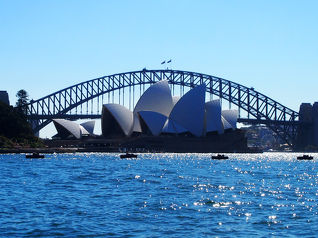
シドニー(オーストラリア) の人気ホテル

オーストラリアで使うWi-Fiはレンタルしましたか?

フォートラベル GLOBAL WiFiなら
オーストラリア最安
305円/日~
- 空港で受取・返却可能
- お得なポイントがたまる
フォートラベル公式LINE@

おすすめの旅行記や旬な旅行情報、お得なキャンペーン情報をお届けします!
QRコードが読み取れない場合はID「@4travel」で検索してください。
\その他の公式SNSはこちら/


0
44