
2006/07/19 - 2006/07/19
339位(同エリア525件中)
![]()
いぶれすさん
この山名を最初に聞いたのは、スイス訪問2回目の1996年のことでした。当時は、ハイキングといっても展望台の近くを散歩する程度で、この時もタウン・ウェアでグラン・サン・ベルナール峠行きのバスをマルティニー駅で待っていたところ、ハイキング・スタイルの人の良さそうな老人二人が同じバスを待っている様子でしたので、何処へいくのかと尋ねた結果、《モン・ブリュレ。簡単に登れる山だよ》とのことで、それ以上話は弾みませんでしたが、二人がLiddesという町で降車したのを何故か良く記憶していました。その後スイス熱が高じて毎年ハイキングに出かけるようになり、標高は低いもののいくつかの名前の付いたピークもハイキング・リスト加わるようなって、この山がターゲットになりました。地図をどう眺めても危険そうな箇所は見つからないからです。コースは、ヴェルビエへの基地ル・シャーブルからの未舗装道路(スイスで経験したのはこの時1回きりです)を走る公共バスの終点、モエ(Moay)が出発地点となります。モン・ブラン山群を眺めながらの稜線歩きの途中で小さなこの頂上に達し、ミーユ峠を経てリッドゥへ降ります。(合計約6時間)尚、同名のピークは複数あり何れも私のようなハイカーには難しい山です。(地図、写真を加えて編集2011/11/16)
Except for this time, I have never experienced a public bus running on partially unpaved road in Switzerland. It is the service for a hamlet called Moay starting from Le Chable at the foot of Verbier.
At Le Chable a colleague driver going for Mauvoisin, also rustic yet more popular destination, showed a sign of two with fingers to ours with a smile.
Yes, we had two passengers including me. And it probably meant, instead of no more than two, no less than two.
But, the third person rode on just a second before departure. She did not sit on seat for passengers, but on front-seat without a word. She seemed to be his wife.
Whichever she might be on business or not, I thought it quite natural.
Who could drive on rough road in dark woods possibly with no passenger so often?
I already heard of the name of this mountain, Mont Brule long time ago, during my early visit of Switzerland when my hiking was limited to walking around, or down from famous lookout points.
In 1996, while waiting for a bus to Col de Grand St. Bernard at Martigny Station, I spoke to two old men of middle seventies in mountaineering wear, and asked where they were going.
They naturally did not show a smile looking at me, not a charming young lady but a shabby oriental middle age in town wear.
But, one of them kindly told me. Mont Brule. Easy walk from Liddes!
With very limited knowledge of mountains at that time, and of course having never heard of Mont Brule, I could not ginger it up any more.
But, I learned after backing home that it was a gain of more than 1200M, and utterly impossible for me.
When I actually decided to climb up this mountain, I never thought to do it like they did. Instead, I relied on Rother's Guidebook of Valais West, of which fore edge was worn by heavy use for the past several years.
By starting from Moay, as described there, total gain of height stays within 1000M. And by descending to Liddes, I could spend the time easier by beer at more populous town with a bit more services of public bus. (Descriptions in English added on 16/11/2011)
-

アクセス:マルティニ→ル・シャーブル→モエ
黄色のマーカーで稜線から遠い方がRotherのガイドブックのコース。
(近い方のコースでモエへ戻るコースも考えましたが、帰りのバス便は、夕刻5時過ぎ一本だけでしたので止めました)
リッドへの下りでは、谷筋のコースをとれば、時間は節約できます。 -
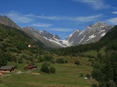
バスの終点モエ(Moay) これだけのの集落です。終点で降りた乗客は私一人。
-
森の中を30分強進むと展望が開け農家のあるラルゼ(Le Larzey)に達します。背後はダン・デュ・ミディ
-
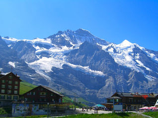
右手はこのようなモン・ブラン山群。谷底はオルシエールの町
-
その後、20分程この様な明るい樹林帯を通りますが、後は見晴らしの良い尾根歩きです。
-
お花畑越しのモンブラン山群。中央の谷の右側はシャンペ湖からリフトで達するブレヤです。
-
左手、バーニュ谷方面。右端の山はモン・ブラン・ドゥ・シェロン(Mont-Blanc de Cheillon)。
-
バーニュ谷方面の遠景。 この辺りはスキー場で少々荒れていますが。
-
遠景にダン・デュ・ミディ(Dents du Midi)。手前の岩峰は、見晴らしが良さそうなラ・クルヴァス(La Crevasse)で、Rotherのガイドブックでもマルティニの南東の稜線、シュマン(Chemin)近辺のハイキングの際には立ち寄ることを勧めています。
-
中央やや右の大きなピークは、エギーユ・ドゥ・シャルドネ、一番左がモン・ドランでしょうか
-
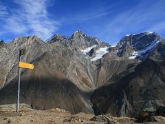
モン・ブリュレ近くの稜線を振り返って。
-
ミーユ峠
-
ミーユ小屋。 頂上を雲に隠しているのはグランド・ジョラス?
-
ミーユ峠付近からのアントルモンの谷とブール・サン・ピエールの街。左の高峰はモン・ヴェラン。


この旅行記のタグ


利用規約に違反している投稿は、報告する事ができます。
コメントを投稿する前に
十分に確認の上、ご投稿ください。 コメントの内容は攻撃的ではなく、相手の気持ちに寄り添ったものになっていますか?
サイト共通ガイドライン(利用上のお願い)報道機関・マスメディアの方へ 画像提供などに関するお問い合わせは、専用のお問い合わせフォームからお願いいたします。
その他の観光地(スイス) の旅行記
その他の観光地(スイス) の人気ホテル


フォートラベル公式LINE@

おすすめの旅行記や旬な旅行情報、お得なキャンペーン情報をお届けします!
QRコードが読み取れない場合はID「@4travel」で検索してください。
\その他の公式SNSはこちら/

0
14